Monday, October 25, 2010
Saturday, October 16, 2010
Finally back home
No pictures. The last 6 and a half hours of driving were incredibly boring. I will have a recap of the whole trip like total miles, etc soon.
Here is today's trek:
View Home at last... in a larger map
Here is today's trek:
View Home at last... in a larger map
Friday, October 15, 2010
Still going home
My GPS pronounces Missouri as "misery". "Take Left on to Misery 15".
Here is a church and an abandoned shack..


I bought a replacement cable but Google maps splits yesterday and today's trek into two pages... Sorry for the four pages:
View Thursday Going Home in a larger map
View Thursday Going Home in a larger map
View Friday still going home in a larger map
View Friday still going home in a larger map
Thursday, October 14, 2010
Tired
I'm at "Lake of the Ozarks" which is in Missouri. I lost the cable to my GPS so I can't upload my map. I have about 13 hours left of driving to make it back home. I'm hoping to do 6+ hours a day.
Iowa and Missouri just didn't appeal to me. I think I'm just too fatigued to stop and take pictures. Here is a touristy type gas station -- sorta cute I suppose.

Iowa and Missouri just didn't appeal to me. I think I'm just too fatigued to stop and take pictures. Here is a touristy type gas station -- sorta cute I suppose.

Wednesday, October 13, 2010
Wednesday Quest for Color
No pictures today. I did pass some pretty scenes but thought it would be better later on. But, the color faded and I ended up empty handed (empty camera?).
Going towards home following the Mississippi for a while to see what its like.
View Wednesday Quest for Color in a larger map
Going towards home following the Mississippi for a while to see what its like.
View Wednesday Quest for Color in a larger map
Monday Road Trip
Chris and I took a road trip... made a big loop. Not much color. We did find a few pretty trees...

Mainly we checked out the Mississippi River. Lots of really dramatic views and scenes but was kinda a bummer in the mostly brown foliage we found.

Found a nice sunset at Big Falls close to their house:

Our trek for the day:
View Monday Road Trip in a larger map

Mainly we checked out the Mississippi River. Lots of really dramatic views and scenes but was kinda a bummer in the mostly brown foliage we found.

Found a nice sunset at Big Falls close to their house:

Our trek for the day:
View Monday Road Trip in a larger map
Monday, October 11, 2010
Sunday going home
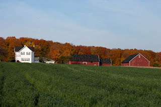
I drove back to Chris and Mike's in Eau Claire. Stopped only once for this farm house. The colors are fading fast. I start going back south probably Wednesday.
My trips log:
View Sunday Going Home in a larger map

My trips log:
View Sunday Going Home in a larger map
Saturday, October 9, 2010
Starting back home
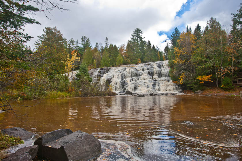
My best waterfall picture so far... Note the blue sky and the detail in the shadows.

My second lighthouse today. It was less than impressive so I waited for a splash and a sea gull to be in the frame to give the picture some interest. Not sure if it works.

Remember "Alice's Restaurant" ? "Took pictures of the approach, the getaway, the northwest corner the southwest corner and that's not to mention the aerial photography." Likewise, I took this guy 26 times (a roll and a half of film). Note how the tower is leaning back. Thats because the camera is pointed slightly up. That can be fixed in photoshop but with the 6x8, the camera tilts and shifts so camera is kept level and the tilt of the tower should not be in the 6x8 cameras shots. We'll see if that is really true.

Just a really picture perfect home I had to take a picture of.

And my trek for the day:
View Saturday Going Home in a larger map
Friday, October 8, 2010
Two strikes
The past two days I've tried to get to Au Sable Point Lighthouse. The road is close from both directions. So, this entry is for the past two days and what I happen to get along the way. The first, of course, is a waterfall. This is Munising Falls.

After some persuasion, I went on the Picture Rocks cruise. The first stop was the Grand Island East Channel Lighthouse. It had nice trees around it. It is no longer in use but still looks cute:

The Picture Rocks are unusual. I don't know really what to do with them except to make modern art from them:

A pleasant picture of Munising WI on the way back from the cruise.

On the second day, one intermediate point was the Grand Marais Harbor Range Light...

The first day's trek:
View Au Sable Try 1 in a larger map
The second day's trek:
View Au Sable Try 1 in a larger map
Wednesday, October 6, 2010
Laughing Whitefish Falls
Got up at 6 am and went to Laughing Whitefish Falls. Hard trek down 153 steps and back up. Plus, the light / scene was extremely contrasty. They told me it would be hard. Here is a shot... might not be my best but none of them are very good.

On the way back, I thought this was kinda cute:

And then I went to Autran Falls. This shot is a composite of three shots at different exposures to try and contain the contrast. Woulda, coulda, shoulda done that at the first place... Oh well.

And my daily trek:
View Laughing Whitefish Falls in a larger map
Tuesday, October 5, 2010
Opps... woke up too late
Well, I drove to "Miner Falls" which is close by, got out, put on my camera backpack which is fairly heavy, hiked 1.2 miles, and got there too late. I had time to take one quick digital picture but the sun was peaking over the ridge I was facing... Oh well. Here is the quick pic:

On the way back, I stopped and took some pictures of the country side and town. These are not touched up much in photoshop. The colors really are that dramatic:


And, of course, the day's trek:
View Opps trip to Miner Falls in a larger map

On the way back, I stopped and took some pictures of the country side and town. These are not touched up much in photoshop. The colors really are that dramatic:


And, of course, the day's trek:
View Opps trip to Miner Falls in a larger map
Monday, October 4, 2010
Wagner Falls
I plan to go back to these falls. It is deep in the woods with no light. The obvious shot is this one:

But I don't like the top half. So, I turned the camera and took this shoot. I think it has a lot more promise.

And, for fun, a nice sunset:

For the curious, here is my trek for the day.
View Trip to Wagner Falls in a larger map

But I don't like the top half. So, I turned the camera and took this shoot. I think it has a lot more promise.

And, for fun, a nice sunset:

For the curious, here is my trek for the day.
View Trip to Wagner Falls in a larger map
Sunday, October 3, 2010
Sunday in Munising
Woke to 33 degrees but clear skys. Fog lifting up off the lake:

Plotted some falls to see and noticed I had past Scott Falls when I drove in yesterday. It was close by so I found it.

Then just tooled around and found a pretty road...

And, finally a map of today's adventures:
View Sunday at Munising in a larger map

Plotted some falls to see and noticed I had past Scott Falls when I drove in yesterday. It was close by so I found it.

Then just tooled around and found a pretty road...

And, finally a map of today's adventures:
View Sunday at Munising in a larger map
Saturday, October 2, 2010
Camping at Kitchi Gami
I troddled over to Munising MI today into fairly cold, windy, and sometimes wet weather. It is raining outside my tent right now. I broke out the Antarctic jackets when I was pitching the tent. Go ahead and call me a wimp but at least I'm here doing this... Where are you?

The GPS, on its own, decided to take me to Bond Falls. There are more evergreen trees here and it seems drier. Still some neat pictures:

Here is a picture of the weather at the lake towards sunset. Pretty neat clouds.

Here is the path for the day:
View Cabin to Munising in a larger map

The GPS, on its own, decided to take me to Bond Falls. There are more evergreen trees here and it seems drier. Still some neat pictures:
Here is a picture of the weather at the lake towards sunset. Pretty neat clouds.

Here is the path for the day:
View Cabin to Munising in a larger map
Moving on... Saturday Oct 2nd
I plan on moving on from my cousin's cabin to Munising, MI. This is up on the coast of Lake Superior.
Here are a few pictures. One would be good to use as wallpaper. The others I took on the 1st. The last is a picture of "The Wooden Tent" as my cousin and her husband call it.


Here are a few pictures. One would be good to use as wallpaper. The others I took on the 1st. The last is a picture of "The Wooden Tent" as my cousin and her husband call it.


Another day, Another Prop -- Sep. 29th
My cousin suggested using the canoe for a prop. This is my third attempt.


Relaxing -- Tuesday morning Sep. 28th
One of the "props" that I use is two chairs looking out over a scene. This was suggested to me by a friend several years ago. This image is actually a composite of three images taken at different exposure to capture the wide range. Anyhow... enjoy:


Subscribe to:
Posts (Atom)